 Arsenal
.
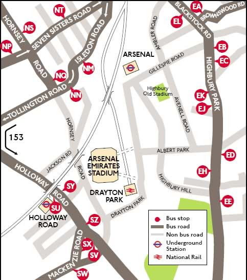
The Emirates Stadium is situated in North London.
Parking is very restricted so the best advice is to take the underground train on the Piccadilly line. Arsenal station is just three minutes walk from the Emirates Stadium.
By Train.
Arsenal underground station on the tube is just three minutes walk from the Emirates Stadium.
By car.Supporters are strongly advised not to drive to Emirates Stadium. The ground is situated in a mainly residential area with an extensive Event Day Parking Scheme in operation. Only car owners with resident's permits will be allowed to park on-street in the designated areas and any cars parked illegally will be towed away.
 Aston Villa.
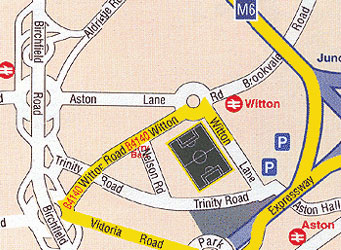
Villa Park is situated two miles north of Birmingham city centre. Do not park in the streets by Villa Park and use the ample spacing car parks.
By train.Change at Birmingham New Street and take the short journey to Witton Station which is just two minute's walk to Villa Park
By car.From the M42 turn off at junction 7 to the M6. Turn-off at junction 6 onto the A38 (M) Aston Expressway before taking your first exit right onto Victoria Road. Turn right at the roundabout into Witton Road for Villa Park.
 Blackburn Rovers.
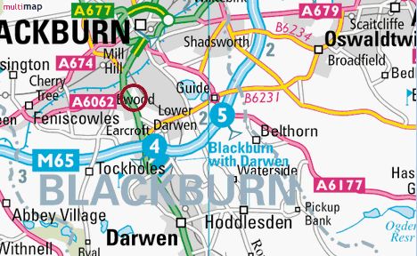
The nearest railway station for Ewood Park is Blackburn and supporters travelling from Liverpool should change at Preston.
By carTurn-off the M6 at junction 31 onto the A59/A677 into Blackburn and after 1 � miles the road splits, so keep on the A677. After about five miles turn right at the Esso garage onto Montague Street then a left into Canterbury Street. Follow the one-way system until the T-junction with the Bolton Road A466 then turn right for Ewood Park.
 Bolton Wanderers.
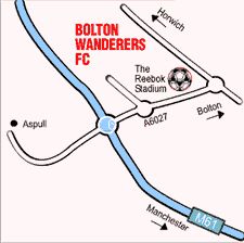
The Reebok Stadium is centrally located in Bolton. The stadium is clearly signposted off junction 6 on the M61. The nearest rail station is Horwich Parkway right by the stadium.
By car.Turn-off the M61 at junction 6 and follow the signs for Reebok Stadium. For the away supporters car park go straight over the roundabout keeping the stadium on your left, the carpark is next left right infront of the stadium and costs approx £6.00
 Birmingham City.
Birmingham City play at St Andrews which is easily accessible from the M6 Motorway.
By train.The nearest railway station is Bordesley which is a 10 minute walk from St Andrews. The mainline station Birmingham New Street is 20 minutes away.
By car.Turn off the M6 at junction 6 and onto the A38 M Aston Expressway. Continue straight on past the first exit then exit at the junction that is signposted Convention Centre/NIA and Ring Road. At the roundabout at the top of the slip road turn left onto Dartmouth Middleway, signposted A41 and A45, Stratford and Coventry. Go straight over the next three roundabouts and under two railway bridges. At the fourth roundabout (Garrison Circus) turn left onto the Coventry Road towards Small Heath and you will see St. Andrews.
 Chelsea.
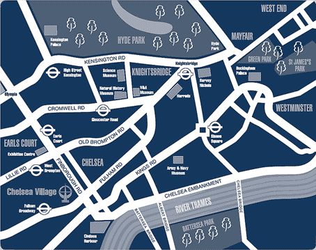
Stamford Bridge is in Central London and parking restrictions apply during the game. There is limited on-site matchday underground parking but it will cost you �20 per car. The best advice is to travel by tube with Fulham Broadway a stone throw away on the District Line
By car.Turn off the M1 at junction 1 and onto the A406 North Circular Road, then onto the A40 until the junction with the M41. After turning right onto the M41 continue for about one mile before turning onto the A3220 Holland Road. From the A3220 turn right onto the A304 Fulham Road and Stamford Bridge is a quarter of a mile along on the right.
 Derby County.By train.
Derby mainline station is a 15 minute walk from Pride Park Stadium. When leaving the train please use the footbridge from the station directly into Pride Park.
By car.Leave the M6 at junction 16 towards Stoke on Trent. Take the A50 Stoke-Derby link road and join A38 towards Derby, and follow signs for Pride Park.
 Everton.
Goodison Park is two miles north of Liverpool city centre, opposite Stanley Park, and there is plenty of car parking spaces available. Nearest main line railway station is Liverpool Lime Street which is in the town centre and two miles from Goodison Park. Kirkdale railway station is on the Merseyrail network and is just a 10 minute walk from the ground.
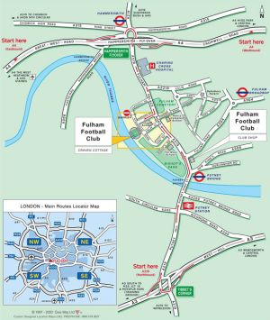
 Fulham.By car.
Take the A1/M1 to North Circular A406 follow signs for Harlesdon A404, then take the A219 to Hammersmith, when on Broadway follow signs for Fulham, turn right after 1 mile into Harboard Street then left at the end for the ground

By Car - For General Parking
From the West
Approach Hull from the M62, which leads straight onto the A63.
Continue on the A63 under the Humber Bridge. The road continues into the A63 Clive Sullivan Way.
Continue along Clive Sullivan Way. Turn off onto the slip road just before the fly-over, sign-posted 'Local Traffic/Infirmary' and for KC Stadium.
At the roundabout, take the second exit "Rawling Way"
At the next main set of traffic lights (and with the Hospital in front of you), take a left turn onto A1105 Anlaby Road. Continue over the fly-over. At the foot of the fly-over, take a right turn into Walton Street.
The Walton Street car park is located just over half way down this street after the Sports Arena.
From the Humber Bridge
Once over the Humber Bridge, follow signs for Hull City Centre. The road follows round to the left to join the A63 Clive Sullivan Way and will take you under the Humber Bridge.
Continue along Clive Sullivan Way. Turn off onto the slip road just before the fly-over, sign-posted 'Local Traffic/Infirmary' and for KC Stadium.
At the roundabout, take the second exit "Rawling Way"
At the next main set of traffic lights (and with the Hospital in front of you), take a left turn onto A1105 Anlaby Road. Continue over the fly-over. At the foot of the fly-over, take a right turn into Walton Street.
The Walton Street car park is located just over half way down this street, after the Sports Arena.
From the North
Take the A1079 towards Beverley then follow signs for the Humber Bridge and the A164. Take the A63 sign-posted Hull City Centre.
Continue on the A63 under the Humber Bridge. The road continues into the A63 Clive Sullivan Way.
Continue along Clive Sullivan Way. Turn off onto the slip road just before the fly-over, sign-posted 'Local Traffic/Infirmary' and for KC Stadium.
At the roundabout, take the second exit "Rawling Way"
At the next main set of traffic lights (and with the Hospital in front of you), take a left turn onto A1105 Anlaby Road. Continue over the fly-over. At the foot of the fly-over, take a right turn into Walton Street.
The Walton Street car park is located just over half way down this street, after the Sports Arena.
From the East & Hull Docks
The A165 approaches Hull from the East Coast and onto Holderness Road. Follow signs for A63/M62 Leeds
At the second large roundabout on the A63 Garrison Road, continue over Myton Bridge straight onto A63 Castle Street. Continue along the A63. Just before the flyover, take the slip road signposted "Infirmary/Anlaby A1105", and at the roundabout take the 3rd exit onto 'Rawling Way.'
At the next main set of traffic lights (and with the Hospital in front of you), take a left turn onto A1105 Anlaby Road. Continue over the fly-over. At the foot of the fly-over, take a right turn into Walton Street.
The Walton Street car park is located just over half way down this street, just after the Sports Arena.

 Manchester City.
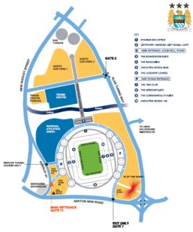
The City of Manchester Stadium is within easy reach just off the M62 and is well signposted. Amongst the benefits the City of Manchester Stadium brings is the improved transport access. There are over 2,000 car parking spaces on site, and a further 8,000 accredited car parking spaces in easy reach of the Stadium.
By car.Leave the M62 at Junction 18 and then join the M60 Ashton Under Lyne. Then follow directions as above.
Amongst the benefits the City of Manchester Stadium brings is the improved transport access. There are over 2,000 car parking spaces on site, and a further 8,000 accredited car parking spaces in easy reach of the Stadium.
 Manchester United.
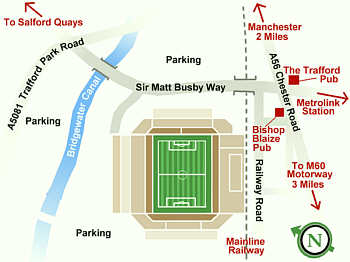
Old Trafford is two miles south-west of Manchester city centre and car parking is available around the ground. The nearest Metrolink stations are Old Trafford which is a short walk past the cricket ground and Trafford Bar, which is a slightly longer walk.
By car.Coming in from the M61 at junction 1 turn onto the M602 and stay on this road for four miles. Turn-off at junction 3 and onto Trafford Road, then after about one mile turn right again into Trafford Park Road, and Sir Matt Busby Way and Old Trafford are on the left.
 Middlesborough.
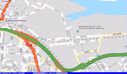
The Riverside Stadium is in the Middlehaven development area which is a 15 minute walk from the town centre. Limited car parking is available at the close by Readman Car Park but fans are encouraged to park in the town centre and walk to the ground. For those wishing to travel by train Middlesbrough mainline station is situated on Albert Road which is just a 10 minute walk from the ground.
By car.Turn-off the A1 (M) at junction 57 onto the A66 (M) and stay on it until the end. Then turn on to the A66 for about 20 minutes before turning left at the roundabout into Forest Road with the ground straight ahead.
 Newcastle United.
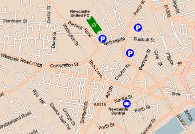
St James' Park is situated half a mile from Newcastle city centre. There is no car parking at the ground but limited parking is available on Barrack Road. The nearest mainline railway station is Newcastle Central which is half a mile away from St James' Park but the very efficient metro system runs every three to four minutes direct to St James' Station, right outside the ground!
By car.Coming up the A1 (M) turn-off at the junction with the A1 and then on the A1 until the junction to turn onto the A184. From the A184 go straight on until you bear left onto the A189, then crossing over the River Tyne on the Redheugh Bridge go straight on at the roundabout onto Blenheim Street and straight through until you come to Bath Lane. Turn left then right into Corporation Street and left at the roundabout into Gallowgate, before the ground is straight ahead at the roundabout of Barrack Road.
 Portsmouth.
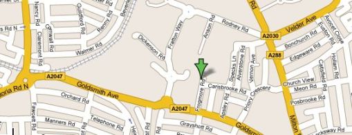
 Fratton Park is situated by Fratton train station, just on the outskirts of the city centre. Once you have got off the train go over the footbridge and you will be in Goldsmith Avenue. Turn left along Goldsmith Avenue and Frogmore Road is about half a mile along there on the left. The entrance to the Fratton End (KJC Stand) is at the bottom of Frogmore Road, as is them entrance to the South Stand.
By train.The nearest station is Fratton
Most of the trains coming into Portsmouth city centre stop there. Once you have got off the train go over the footbridge and you will be in Goldsmith Avenue. Turn left along Goldsmith Avenue and Frogmore Road is about 1/2 a mile along there on the left. The entrance to the Fratton End (KJC Stand) is at the bottom of Frogmore Road, as is them entrance to the South Stand.
By car.Coming on the M6 turn off at junction 4a with the M42 branch left (sign posted London M40/N.E.C./Solihull) to join M42. Then at junction 3a branch left and follow London signs to join M40. Leave M40 at junction 9 (A34/41) sign posted Oxford and at roundabout take the third exit for the A34.
At the junction with the M4 take the second exit off the roundabout and follow the A34 until the junction with M3. Take the third exit off roundabout to join M3. After Junction 14 follow the sign posted Portsmouth M27) and then join the M27.
At Junction 12 branch left (sign posted Cosham A27). In 0.4 miles at junction with A3/A397 take the third exit off the roundabout to join A3 (sign posted Chichester). In 0.9 miles at junction with A288 branch left and follow signs for Southsea (A228).
At the roundabout take your second exit and at the junction with A2030 at roundabout take the second exit. In 0.4 miles at junction with A2030(s) at traffic lights turn right onto A2030 (sign posted City Centre, Fratton). In 0.3 miles turn right and Fratton Park is directly ahead.
 Reading.By train.
The nearest train station is Reading. From outside the station take the fast track park and ride green bus direct to the stadium. Average journey time is less than 10 minutes.
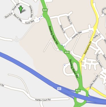
By car.From the M4 come off at junction 11 and follow signs towards Reading. The Madejski Stadium will appear on your left hand side after less than a mile. There is ample parking on site at the stadium and many surrounding car parks.
 Tottenham Hotspur.
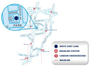
White Hart Lane is in North London which is six miles from the city centre, and limited car parking is around the ground. For those travelling by train the nearest mainline railway station is White Hart Lane which is just three minutes walk away. Change at Charing Cross for the train to White Hart Lane. The nearest tube station is Seven Sisters on the Victoria Line which is 1½ miles away.
By car.Coming into London from the M40, at junction 1 stay on the A40 before you turn onto the A406 North Circular Road for 13 miles until you reach the Edmonton traffic lights onto the A1010 Fore Street and after about one mile White Hart Lane is on your left.
 Sunderland.
The Stadium of Light is situated on the banks of the River Wear, on the outskirts of Sunderland City centre. Its location makes it easily accessible by all means of public transport.
By train.Sunderland train station is about 10 to 15 minutes walk from the stadium.
By car.Take the A19 North and South. Then take the A1231 signposted Sunderland North. After four roundabouts keep to the left hand land and follow signs for the B1289 (signposted Roker). Continue on this road and you will see the stadium on your right.
 West Ham United.
West Ham United FC is easily accessible by train on the London Underground, and has it's own tube station Upton Park.
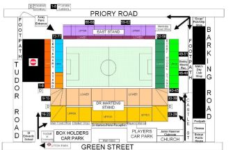
By train.Take the underground to Upton Park tube station, which is on the District Line. The ground is only around the corner from the station. Turn right along Green Street past the market and the ground is a bit further down on the left hand side.
By car.Take North Circular (A406) to A124 (East Ham), then on Barking Road for approximately 1.5 miles until you approach the traffic lights on crossroads. Turn right into Green Street, ground is on the right hand side.
From The East
Use A13 (signposted London) then at crossroads turn right A117. In 0.9 miles at crossroads turn left into Green Street for West Ham United FC.
 Wigan Athletic.
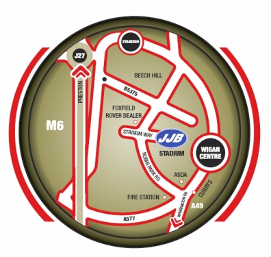
Wigan Athletic play at the JJB Stadium which is easily accessible from the M6 motorway.
By car.Exit the M6 at junction 26 and follow the signs for Wigan. Turn right at the traffic lights at the top of the slip road and then follow the road through Pemberton for about 2 miles until you reach the road junction near Aldi. Turn left at these traffic lights, and then proceed along this road, turning right at the second set of lights into Scot Lane. You should enter the Robin Park Complex with the JJB Stadium ahead of you.
